Tired of crowded trailhead parking, outrageously smelly outhouses, the startling sound of dinging bells behind you and hoards of riders running you off the trail? If you’re looking to escape the masses of Fruita and Moab in search of a peace and solitude on the trail, Norwood, Colorado is the place to be!
Located just two hours from both Grand Junction and Moab, and just 40 minutes from both Telluride and Ridgway, Norwood is perfect for a quick day trip or fun weekend getaway! With two new singletrack trail systems, miles upon miles of high desert and alpine trails for your mountain biking pleasure, along with its expansive views and ideal seasonal climate, Norwood is jam-packed full of unlimited opportunities and a variety of terrain for every skill level.
Read on to explore our local trails and see for yourself why Norwood is becoming an ultimate Western Colorado mountain biking destination and should be on your list of places to ride in and around the Four Corners region!
Burn Canyon Trails

The Burn Canyon Trail system features four different loops and nearly nine miles of easy to moderate, fun, flowing and family-friendly singletrack. Developed by Norwood’s Park and Recreation District, the Burn Canyon Trails sit at around 7,000 feet and offer intermittent views of Naturita Canyon, McKee Draw, Paradox Valley, Utah’s La Sal Mountains, Lone Cone Peak and the San Juan Mountains.
The smooth, tacky trails bounce and dart through forests of juniper, pinion and sage brush. Burn Canyon offers the longest riding season on Wright’s Mesa. Spring offers ideal, warm temperatures and colorful sightings of high-desert wildflowers. Summer rides should be done in the mornings and evenings as temperatures reach the high 80s and low 90s. Much like spring, fall offers perfect temperatures with warm sun and cool shade.

The Burn Canyon Trail System is split into two different sections of loops, connected by a spur. Each loop in the system is between 1 and 2.5 miles in length. Buttermilk Loop, the first loop from the trailhead is the easiest trail in the system and is suitable for all ages and abilities. Pinyon Point Loop is a continuation of Buttermilk Loop and offers slightly more technical riding along with views of the surrounding canyons and the La Sal Mountains. Connecting the second loop section is the Old Nelson Cut-off which passes along the edge of Hideout Canyon and offers the only major climb in the system along with couple of challenging switchbacks. Cedar Post Loop is a shorter, fun and fast loop. Hideout Canyon is a continuation of Cedar Post Loop and is the most challenging loop in this trail system with more intermediate technical riding. Posey’s Spur Trail connects back to Norwood Burn Road for an easy ride back to the parking area.
How to get there
The Burn Canyon Trail System is located 3 miles west of Norwood. The trailhead is easily accessible by vehicle or can be ridden by bike from town. From Norwood, follow Highway 145 west out of town. Approximately one mile after leaving town (past the fairgrounds), turn left (west) onto County Road AA42 Road (Norwood Burn Road). After about 1 mile the road changes to gravel before dropping into Naturita Canyon. Continue down into Naturita Canyon, cross Naturita Creek and soon after pass a sign on the left for the McKee Draw hiking trails, continue climbing this road as it switchbacks back up to the top of the canyon. The large parking lot for the trailhead appears at the top of the canyon on the right.
Check out the West End Trail Alliance website for more information, maps, GPS and directions for Norwood’s Burn Canyon Trail system!
It’s important to pay attention to seasonal wildlife closures. To protect wildlife and their habitat, the Burn Canyon Trails are closed to mountain biking from December 1 to April 30, during which time the trails are open to foot (hiking and equestrian) traffic only.
Thunder Trails

The Thunder Trails are the largest trail system on Wright’s Mesa, offering four loops and 19 miles of fun, fast and flowing trails, as well as challenging climbs and moderately rocky and technical singletrack. The Thunder Trails offer views of Naturita Canyon and Lone Cone Peak while meandering through ponderosa and oak brush forest as well as grassy meadows.
The riding season at the Thunder Trails starts as soon as the snow melts and the mud dries, typically late April into early May. The season begins as the first hint of spring appears and groves of purple pasque flowers line the trails.

Being around 500 feet higher in elevation than the Burn Canyon Trails, the Thunder Trails offer summer-long riding under the cool shade of towering ponderosa pines. Fall offers some of the best temperatures for riding while the oak brush leaves begin to change color.
The four loops that make up the Thunder Trails system each range from 3.5 to 4.5 miles in length. Each loop can be connected and ridden as a loop or on the east or west sides as an out-and-back. The east side of the trail system is the easiest, offering more variety of smooth, rocky and flowing singletrack, while the west side of the system along Naturita Canyon offers more technical, rocky singletrack.
The first trail, Thunder Loop is the most popular as it takes off from the main trailhead and offers the best variety of riding with fast and fun downhill, smooth and flowing singletrack, technical rock outcrops and challenging climbs. The last three loops in the system, Naturita Rim Loop, Portis Loop and Goshorn Loop intertwine along the top of Thunder Road. The least technical riding featuring smoother and faster singletrack can be found along the east side of these loops. The west side of these loops offers generous views of Naturita Canyon and Lone Cone Peak and features rougher singletrack, scattered with more challenging rock sections. Each loop in the trail system can be accessed along Thunder Road with small parking areas where each trail intersects with the road.
How to get there
The Thunder Trails are located approximately 4 miles south of Norwood, on Thunder Road and are easily accessible by vehicle. Head to Norwood’s west side, travel along Highway 145 until it intersects with Aspen Street (County Road 42ZS). Travel south 1 mile and turn right onto County Road Y43. Travel 1/2 mile and turn left on County Road 41.5Y (see a large brown “National Forest Access” sign). Travel south 1.7 miles (the paved road will turn into gravel), then turn right onto Forest Service Road 609. Follow the National Forest Road for 1.2 miles and the Thunder Trails Trailhead parking area will appear on the left.
Check out the West End Trail Alliance website for more information, maps, GPS and directions for Norwood’s Thunder Trails system!
Looking to camp and bike? Not a problem, just set up camp and ride! At Norwood’s Thunder Trails, dispersed camping can be found along Thunder Road in designated National Forest campsites, two miles south of the main trailhead within the Thunder Loop.
Best Singletrack Trails For Beginners and Advanced Riders

Our pick of the best trails in Norwood for mountain bikers just starting out:
- Buttermilk Loop, Burn Canyon Trails
- Pinyon Point Loop, Burn Canyon Trails
- Naturita Rim & Portis Loops (east side only), Thunder Trails
Our pick of the best trails in Norwood for more advanced mountain bikers:
- Old Nelson Cut-off, Burn Canyon Trails
- Hideout Canyon, Burn Canyon Trails
- Thunder Loop, Thunder Trails
- Thunder Trails (all loops, west side only)
Other Options For Mountain Biking Around Norwood

If you’re looking for more adventure and exploration, Wright’s Mesa offers even more options for mountain biking! Norwood is surrounded by miles and miles of county and National Forest roads. Mountain and gravel bike enthusiasts can enjoy putting miles under their tires with scenic rides around Lone Cone Peak.
Follow Lone Cone Road (County Road 44ZS) where the pavement ends. From here the road splits with options to follow the Dolores-Norwood Road (Forest Service Road 526) or Beef Trail Road (County Road M44) which leads to either Specie Mesa or Beaver Park. Riding the gravel County Road M44 across Specie Mesa offers vast views of the San Juan Mountains until its intersection with Colorado Highway 145.

Forest Service Road 611 through Beaver Park offers more challenging mountainous riding along National Forest Roads around Lone Cone Peak. Mountain bikers can enjoy challenging climbs and fast down hill riding through dense aspen forests on the National Forest roads surrounding Lone Cone Peak. An option for singletrack mountain biking around Beaver Park includes the Gurley Ditch Trail which can be accessed in two locations along National Forest Road 611. Continuing west along National Forest Road 611 past Beaver Park leads to an intersection with Fall Creek Road (County Road 57P) with options to continue on to Woods Lake and Wilson Mesa outside of Telluride.
From the Dolores-Norwood Road (Forest Service Road 526), cyclists have a number of options riding around the west side of Lone Cone Peak. One option is to to continue along the Dolores-Norwood Road toward Groundhog Reservoir. From there, cyclists can turn left toward Groundhog Reservoir and ride to the resort town of Dunton, or even Lizard Head Pass. Cyclists can also continue along the Dolores-Norwood road, ultimately ending in Dolores. Another option is to turn right and head toward Miramonte Reservoir, following County Road U29 which leads to Dry Creek Basin and Colorado Highway 141.
When’s The Best Time To Mountain Bike Around Norwood?

We recommend starting the mountain bike season in the deserts of Colorado’s West End. For a quick and fun riding fix, head to Nucla and check out the new Nucla Range Loops adjacent to the Paradox Trail. Or, if a more technical mountain bike adventure is what you’re looking for, the Shamrock (Y11) Trail along the cliff sides of the San Miguel and Dolores Rivers will be sure to get your adrenaline pumping with steep cliffs and killer canyon views! Once the snow on Wright’s Mesa melts, move up to the Burn Canyon Trails while the wildflowers are blooming. As summer approaches and temps start to heat up, head on over the the Thunder Trails to stay cool under the ponderosa pines. Once summer is in full swing, it’s time to head up to the alpine and ride the National Forest Roads surrounding Lone Cone Peak. Hang out up high until fall to catch the changing colors, then migrate back down to lower elevations as the temperatures cool.
Gear, Pizza and Beer!

That’s right, Norwood, Colorado has all the essentials for your next mountain bike adventure! Maggie’s Pizza is there to help you carb-load and recover from a long day on the trails with delicious handmade pizzas, appetizers, salads and sandwiches as well as beer on tap. Dine in, call in and order ahead of time, or take your pizza to go! For mountain bike gear and more information on trails and mountain biking around Norwood, the friendly folks at High Country Bicycles are happy to help with your mountain bike needs, including demos and rentals!
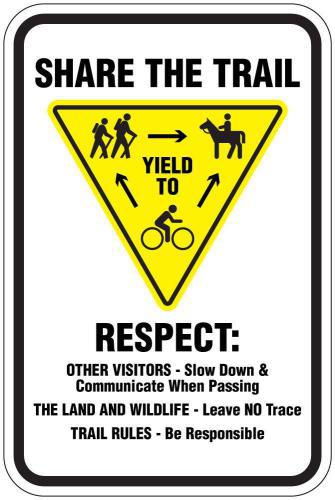
The Importance Of Trail Etiquitte
Many of the trails surrounding Norwood are considered multi-use trails, meaning they are shared between different user groups including mountain bikers, dirt bikers, hikers and horseback riders. The general rule goes: Mountain bikers yield to horses and foot traffic, and descending riders yield to climbing riders.
It’s also important to remember that the environment and landscape of Wright’s Mesa is delicate. As mountain bikers, our actions have critical impacts on the landscape, the trails, the animals and other trail users.
The International Mountain Biking Association (IMBA) established its Rules of the Trail to educate mountain bikers of the basic guidelines for responsible riding. Please remember to follow these guidelines to help keep the peace and preserve our landscape!

If you’re looking for places to stay ad camping isn’t your thing, check out Norwood’s lodging opportunities HERE! And for more information on our BLM and National Forest public lands, visit https://www.fs.usda.gov/main/gmug/home or https://www.blm.gov/colorado